Tuesday, 5 July 2011

Amber Fort

Amber Fort is located in Amber (Jaipur), which used to be the capital of the Kachhwaha clan, till Jaipur was made the official capital in 1727. The Amber Fort looks stunning, all-built in white marble and red sandstone. To add to its charm, Maotha Lake makes its foreground. 
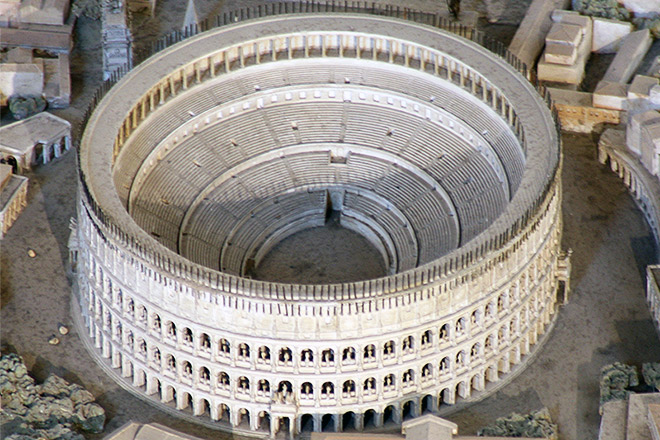
The crystal mirror image of the Fort, on the still waters of the lake, seems to be a beautiful illusion. Amber Fort is usually pronounced as Amer Fort. In 1592, construction of the Fort was started by Raja Man Singh I. However, 
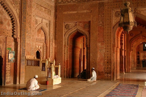
the Amber Fort took its present form during the reign of Raja Jai Singh I. The outer appearance of the Fort, being rough and craggy is totally different from its core. The interior of the Fort provides a soothing and warm ambience, which is least expected from its outer appearance. The marvelous decoration of the Amer Fort is influenced by both, the Hindu and Muslim manner of ornamentation. Exquisite paintings of hunting scenes on the walls depict the temperament of the Rajputs, who were adventurous, revolutionary and self-indulgent. The intricate carvings on the walls and ceilings simply astonish the visitors. The minute mirror work adds to the grand appearance and royalty of the halls. The Amer Fort undoubtedly captivates the tourists with its artistic quality of delicate work. The mighty walls guarantee the protection of the Fort against the invasion of the enemies. The Fort is divided into four subparts. Kali Temple, which is also known as Shila Devi Temple, forms the part of the Fort. It is renowned for its glorious past, huge silver lions and silver doors. The Hall of Public Audiences, Diwan-I-Aam is a pavilion with double row of columns. Ganesh Pol, another feature of the Fort, directs the way to the inhabited apartments of the King. The Hall of Victory, Jai Mandir has a stunning ceiling comprised of mirror work and an inlaid panel. The Fort has numerous other halls and pavilions with their own specific attraction. The best part of this tourist attraction situated on a crafty hill, is the royal elephant ride. The flawless beauty of the Fort can be enjoyed royally with an elephant ride. Amber/Amer Fort is the part of Jaipur and its royalty. A trip to Jaipur would be definitely incomplete, without the visit to this imperial Fort of Amber. 

 Location  On Delhi-Jaipur Highway, 11 km from Jaipur
Built by: Raja Man Singh I 
Built in: 1592 
Highlights: Wonderful carvings and minute mirror work
How to reach: You can reach Amber Fort either by taking local buses from the city or by hiring Taxis 

 H!story Of  Amber Fort 


Raja Man Singh built Amer Palace in 16th century. It is a mesmerizing blend of Hindu and Mughal architecture. Rajputs made use of this Amber Fort from the 16th century up to the foundation of Jaipur in 1727. The Amber Fort was used by the Rajputs both for defense purpose as well as the residential purposes. Thus within its mighty walls, one finds charming gardens and magnificent palaces made from marble and precious stones, richly decorated with intricate stonemason works and paintings, which represented royal splendor and luxury. Situated at Jaipur, the reflection of Amber Fort in the lake below looks almost divine. It is not at all surprising to know that this majestic and stately fort was once the Capital of Minas. Amer Fort houses Jai Mandir, a famous temple which has Sheesh Mahal, a beautiful hall of mirrors that are so artistically set that even a tiny ray of light gets reflected in the mirrors and illumines the hall dazzlingly. Sheesh Mahal is famous all over the world as one of the most desirable tourist attraction. Other places of interest in this fort are Sukh Niwas and Ganesh Pole. 


 Amber Fort Attractions  


Amber fort was built in red sandstone and white marble. The palace complex has some very interesting apartments, the likes of which are not to be found anywhere else in the country. Jai Mandir, Sheesh Mahal, Sukh Niwas, Ganesh Pol are some of the prominent areas of interest.

On one bastion of this fort called Deewa Burj 
a high tower stands which was previously used 
as search light house, indicating location of the Fort. The Entrance to the great courtyard on 
the lower terrace of the palace is through an 
imposing archway. Both sides are covered 
with the bases of Palaces and barracks. 
The royal Palace on the left extremity 
of the enclosure is approached by a long flight of steps through a double gate-way, called Singh Pol, which opens in to Court of Diwan-i-Am. The kali temple is situated behind this pol. The silver plate studded doors of the temple built of white marble is an admirable piece of great beauty. 

  Front View Of Amber Fort  


Humayun's Tomb

Humayun died in 1556, and his widow Hamida Banu Begam, also known as Haji Begam, commenced the construction of his tomb in 1569, fourteen years after his death. It is the first distinct example of proper Mughal style, which was inspired by Persian architecture. It is well known that Humayun picked up the principles of Persian architecture during his exile, and he himself is likely to have planned the tomb, although there is no record to that effect. The tomb was constructed at a cost of 15 lakh rupees (1.5 million). Mirak Mirza Ghiyath, a Persian, was the architect employed by Haji Begam for this tomb.The tomb proper stands in the centre of a square garden, divided into four main parterres by causeways (charbagh), in the centre of which ran shallow water-channels. The high rubble built enclosure is entered through two lofty double-storeyed gateways on the west and south. A baradari (pavilion) occupies the centre of the eastern wall and a hammam (bath chamber) in the centre of northern wall.The square red sandstone double-storeyed structure of the mausoleum with chamfered corners rises from a 7-m. high square terrace, raised over a series of cells, which are accessible through, arches on each side. The grave proper in the centre of this cell-complex is reached by a passage on the south. The octagonal central chamber contains the cenotaph, and the diagonal sides lead to corner-chambers which house the graves of other members of the royal family. Externally each side of the tomb, its elevations decorated by marble borders and panels, is dominated by three arched alcoves, the central one being the highest. Over the roof pillared kiosks are disposed around the high emphatic double dome in the centre. The central octagonal chamber contains the cenotaph, encompassed by octagonal chambers at the diagonals and arched lobbies on the sides. Their openings are closed with perforated screens. Each side is dominated by three arches, the central one being the highest. This plan is repeated on the second storey too. The roof surmounted by a double dome (42.5m) of marble has pillared kiosks (chhatris) placed around it.The mausoleum is a synthesis of Persian architecture and Indian traditions-the former exemplified by the arched alcoves, corridors and the high double dome, and the latter by the kiosks, which give it a pyramidal outline from distance. Although Sikandar Lodi's tomb was the first garden-tomb to be built in India, it is Humayun's tomb which set up a new vogue, the crowning achievement of which is the Taj at Agra. There is also a somewhat common human impetus behind these two edifices-one erected by a devoted wife for her husband and the other by an equally or more devoted husband for his wife. Several rulers of the Mughal dynasty lie buried here. Bahadur Shah Zafar had taken refuge in this tomb with three princes during the first war of Independence (AD 1857). On the southwestern side of the tomb is located barber's tomb (Nai-ka-Gumbad) which stands on a raised platform, reached by seven steps from the south. The building is square on plan and consists of a single compartment covered with a double-dome.

Open from sunrise to sunset 
  Spectacular Mughal Buildings 


One of the most spectacular Mughal buildings, Humayun's tomb was added to Unesco's World Heritage List in 1993. Built by Haji Begum, the widow of Humanyun, the second Mughal Emperor, the mausoleum is known to the precursor of world famous Taj Mahal. Built with a cost of one and a half million rupees, the monument heralded the construction of garden-tombs on the Indian subcontinent. Experience the majesty of Humayun's tomb with Hotels of New Delhi.

As soon as one enters the massive double-storeyed gateway, the majesty of the building becomes self-evident. High walls surrounds a square garden which is divided into four large squares separated by causeways and water channels. Each square, in turn, is divided into smaller squares by pathways. This forms a typical Mughal garden known as charbagh. Highly developed engineering skills were employed in the working out of the fountains. Though made of red sandstone, black and yellow stone was used to give variation. Humanyun's Tomb came into the scene during the First War of Indian Independence in 1857. When the uprising failed, Bahadur Shah II, the last Mughal emperor, took refuge in the tomb, before he was sent to the Rangoon jail in Myanmar. The tomb stands majestically at the center of the enclosure and rises from a platform faced with a series of cells with arched openings. The complex of Humayun's Tomb contains many small monuments. Chief among them are black-and-yellow marble tomb of Humayun's wife and the tomb of Humayun's barber. Referred to as Nai Ka Gumbad, the barber's tomb is an impressive square tomb with a double-dome 

 Isa Khan's Tomb 

The Tomb of Isa Khan, located outside the main grounds of Humayun's tomb, was built in 1547. It /HumayunsTomb1.jpgcommemorates an important notable who served Sher Shah, the Afghan ruler of Delhi who had ousted Humayun. The octagonal form of the tomb has a long history in Islamic art and became popular in India in the second half of the fourteenth century for members of ruling families. A possible direct model for Isa Khan's tomb is the tomb of Sikandar Lodi (not shown here), built three decades earlier in Delhi. To the untrained eye, the tomb of Isa Khan has the more graceful proportions. Its particular evocation of the form is noteworthy for the elegant clustering of chhatris (kiosks) and pinnacles around the dome, features which were absent on the Lodi tomb.


Jama Masjid

Jama Masjid of Delhi is the largest mosque in India. The Jama Masjid stands across the road in front of the Red Fort. Built between 1644 and 1658, Jama Masjid is one of the last architectural works of the Mughal emperor Shah Jahan. The spacious courtyard of the Jama Masjid holds thousands of faithful. Jama Masjid is located on a mound in the heart of the old city and projects beautifully into the Old-Delhi skyline. Jama Masjid Mosque was built in red sandstone and marble by more than 5000 artisans. Originally called the Masjid-i-Jahan-Numa, or "mosque commanding view of the world", the Jama Masjid stands at the center of the erstwhile capital city of the Mughals, Shahjahanbad. The Jama Masjid was completed under the supervision of Saadullah Khan, the Prime Minister of Shah Jahan. A sum of Rs 10 lakhs was spent on the construction of the Jama Masjid. The Jama Masjid is built on a red sandstone porch, about 30 feet (10 m) from the level of the ground and is about 1400 square yards (1200 m²) in extent. The Jama Masjid has three gateways, four towers and two minarets. The gateways in the north and south are led by a fleet of steps. The main entrance is on the eastern side facing the red fort. It was probably used by the emperors. The tower of the Jama Masjid is made up of five distinctive storeys. Each one of the storeys has a projecting balcony. The adjoining edifices are beautifully done with calligraphy.  The first three storeys of the Jama Masjid tower are made of red sandstone and the fourth one is made of marble, while the fifth is made of sandstone. The Jama Masjid is covered with intricate carvings and has verses inscribed from the holy Koran. The grand Red fort (Lal Qila) stands on the eastern side of the Jama Masjid. The main prayer hall of the Jama Masjid is made up of high cusped arches and marble domes. The cabinet in the north gate of the Jama Masjid contains a collection of Muhammad's relics - the Koran written on deerskin, a red beard-hair of the prophet, his sandals and his footprints, implanted in a marble block.

  The Biggest Mosque In India  

Near the Red Fort about 500m away is the Jama masjid, the biggest mosque in India. It was begun by Shah Jahan in 1650 and completed six years later and the whole cost about a million rupees. It is hard to imagine a building more suited to evoking the awe of the majesty of Allah in man. The mosque stands on a rocky elevation. Its huge gateway looks down at you like fastidious connoisseur from an immense platform which has steps that lead up to it. Constructed in Sandstone and white marble, Jama Masjid can be entered from both the directions - North and the South Gates. The eastern gateway is supposed to remain open in Friday and was used by the emperor himself. Jama Masjid is cluttered by devotees who offer namaz, especially during Muslim Festival. For those who don't belong to non - Muslim community, a specified time is mentioned to enter the mosque. Beyond the intimidating entrance, is a vast courtyard measuring nearly 100msq. It is flanked by pillared corridors which run all along the courtyard and have domed pavilions in the middle on either side.  The prayer hall, measuring 61m by 27.5m, is quite a marvel. It is has a magnificent façade of eleven arches, the central one being higher than the others and serving as the entrance. It is topped off by three magnificent domes which are richly ornamented and have black and white marble stripes – much like the Nizamuddin Dargah.

 Location 

Located in the centre of the old city, this congregational mosque was built by Sultan Ahmed Shah in 1423. Built in yellow sandstone, it combines the best of Hindu and Muslim styles of architecture, standing on 260 pillars supporting 15 domes at varying elevations.

 Architectural Triumph  

The vast paved courtyard is a rectangle nearly seventy-five metres by sixty-six metres. The whole of the western chamber is a big hall, standing on 260 pillars all carved from Hindu and Jain traditions. The central courtyard is accessible from the East, though there are three ways on the other side too. The Eastern side entrance leads to another enclosure containing the mausoleum of Sultan Ahmed Shah. Thus it is an architectural triumph.

 Tombs  

 
Near the Eastern entrance stands the 'roja' 
or the tomb of the Sultan Ahmed Shah, which was homage to the Sultan by his son Mohammed Shah II. The tomb houses the graves of three great rulers of Gujarat - Ahmed Shah I, his son, Mohammed Shah and his grandson, Qutub-Ud-Din Ahmed Shah II. After a passage of 100 years, a nobleman by the name - Farhatul Maluk repaired the tomb, who also got the walls of the mosque engraved. Today after centuries of heat and rough weather, the Masjid stands unchallenged serving as a prayer place for numerous Muslims residing in the city. Among the most popular sights of the city of Ahmedabad is the Jama Masjid, boasting of a well-proportioned architecture. It took 13 years to complete this fine example of Indo-Saracen architecture of the Ahmed Shahi style. A white marble paved courtyard, with a pool in the middle provides a perfect pause between the raucous streets outside, and the dignity of the main sanctuary within. Nearby the Masjid are Pols and the Teen Darwaza (The Three Gates). Sultan Ahmed Shah built these arched gateways, which were meant as the royal entrance to the Maidan Shah or Royal Square. From here the Sultans used to watch the processions from the palace to the Jama Masjid.

 Sun-Set View Of Jama Masjid 


Angkor Wat

Angkor WatThe beginning of the Angkorian period was shortly after 800 A.D., when the Khmer King Jayavarman II announced the independence of Cambodia and established his capital at the northern end of Tonle Sap.  In 802 Jayavarman rendered his new status by declaring himself “universal monarch.”For the next 300 years, between 900 and 1200 CE,  some of the world’s most amazing architectural masterpieces the Khmer empire produced, were in the area we know as Angkor.  Most of them are in an area about 15 miles east to west and 5 miles north to south. There are 72 major temples or other buildings in this area. The Angkor settlement around the temple complex was over 3,000 km² (1,150 square miles).The main temple is Angkor Wat, built between 1113 and 1150 by King Suryavarman II. After uniting his political position through military  diplomacy,campaigns, and a firm domestic administration, Suryavarman began the construction of Angkor Wat near what is now Siem Reap. With walls on each side nearly one-half mile long, Angkor Wat exudes the Hindu cosmology, and the central towers represent Mount Meru, home of the gods; the outer walls, the mountains enclosing the world; and the moat, the oceans beyond. After defeating the neighboring Cham in 1181, Jayavarman took reign. He was known to be the greatest of the Angkorian kings. Jayavarman built the walled city of Angkor Thom, as well as its geographic and spiritual center, the temple known as the Bayon. Bas-reliefs at the Bayon represent not only the king’s battles with the Cham, but also representations from the life of Khmer villagers and courtiers. Jayavarman also constructed the well-known temples of Ta Prohm and Preah Khan, who he dedicated to his parents. During Jayavarman’s reign, Hindu temples were altered to show images of the Buddha, and Angkor Wat briefly became a Buddhist shrine. The kingdom fell into a period of internal strife following the death of Suryavarman. The year Angkor was rampaged and looted by Thai invaders, was notably the end of the Angkorian period and was generally around 1431 A.D. even though the civilization already had been in decline in the 13th and 14th centuries. During the 15th century, nearly all of Angkor was abandoned, except for Angkor Wat, which remained a Buddhist shrine. Angkor Wat was put on Unesco’s list of World Heritage sites in 1992 after many decades of wear and tear had taken their toll on this site in Cambodia.

Angkor Visitor Information 

isitors to the temples of Angkor must buy an entrance ticket. The ticket sales booths are open from 5 a.m. in the morning to 5:30 p.m. at night. A one day pass is US$ 20, a three day is US$ 40, and a week pass costs US$ 60.Visitors must show their Angkor Pass every time they pass one of the checkpoints and at the entrance to most temples and other monuments in the Angkor Park. The temples are open from sunrise to sunset. Angkor Wat is in western Cambodia near the Thailand border. The nearest town and the launching ground for tours is Siem Reap. The US dollar is the de facto currency of the country. Besides the obvious vast amount of temples, here are some other highlights not to miss while at Angkor: 
Sunrise at Angkor WatSunrise absolutely cannot be missed. Rays of light raised behind Angkor Wat make the whole temple covered with a spectacular and mysterious atmosphere that you must take in. 
The reflection ofthe three towers symmetry of Angkor WatOne of the must-do’s and what most tourist do is jostle themselves for a shot of the reflection of the three towers symmetry of Angkor with the reflection in the pond. Since this is a place of interest with many tourist, this is also a good stopping point if you are alone. You can ask fellow travelers to take your photo with the background as evidence that you were there. 
Siem Reapis the town and providence where Angkor Wat is located. It is only at the beginning of modernization and urbanization, so there are still interesting communities around the temples. This is also a great way to visit neat little markets  and contribute to the local villag 
Bayon TempleIf you only see one other temple besides Angkor Wat, Bayon should be the one. The giant stone faces of Bayon have become one of the most recognizable images connected to classic Khmer art and architecture. There are 37 standing towers, most but not all sporting four carved faces oriented toward the cardinal points. It is best to plan multiple days to see all of the temples, but if time does not allow, Bayon should be on your list.   

 Angkor Conservation Efforts 

The celebrated Angkor temple complex is in great disrepair and is one of the many sites in the world where tourism has been a double edged sword. It currently draws about one million tourists a year, but estimates suggest that over the next few years visitor numbers could swell to as many as five million a year. Such an increase in traffic is something the ancient sandstone structures are ill-equipped to cope. Even before the Communist guerrillas started shooting at it, the temple had to endure centuries of neglect in the humid jungle. Conservation work on the site resumed after the end of the Cambodia civil war, and since 1993 has been jointly coordinated by the French and Japanese and UNESCO through the International Coordinating Committee on the Safeguarding and Development of the Historic Site of Angkor (ICC), while Cambodian work is carried out by APSARA. Some temples have been carefully taken apart stone by stone and reassembled on concrete foundations. The World Monuments Fund has aided Preah Khan, the Churning of the Sea of Milk (a 49-meter-long bas-relief frieze in Angkor Wat), Ta Som, and Phnom Bakheng.Conservation efforts continue year after year in order to preserve the sites not only from the onslaught of tourism but from nature too. Locals are educated on the value of the site and on sustainable tourism methods. Angkor Wat is also under the constant threat of looting.

 Full View OF  Angkor Wat  


TaJ Mahal

Experiencing the Taj Mahal without being cognizant of its history is grossly irrelevant and absurd. The extravagant 
expression has not come easy. There underlays an ocean of emotions and a wild passion that led the king to erect such a masterpiece in snow-white marble. It's a monument, 
the only one, where perhaps, ever inch of the edifice, from one corner to the other, expresses the beauty of Mumtaz Mahal. Mughal emperor's Shah Jahan's intense feelings 
and warmheartedness can be felt at the very first instant as you arrive here to fix your gaze upon one of the most phenomenal structures in the world. The splendid love story begins in 1612, when a Persian princess Arjumand Bano married Shah Jahan (then prince Khurram), the fifth Mughal emperor. Arjumand Bano, who later became known as Mumtaz Mahal (the Chosen of the Palace), was a second wife to the emperor. Both a companion and an advisor, the queen followed the emperor on his journeys and military expeditions. Such was the effect of the queen on his emperor-husband that Shah Jahan was inspired to perform acts of charity and benevolence all throughout his life. 

History of Taj Mahal


 The love story took a serious turn when, on a campaign at Burhanpur with her husband, Mumtaz Mahal took his last breath giving birth to their 14th child. So heartbroken was the emperor that the whole court went into mourning for a span of over two years. It is said that, within a few months after the queen's death, the hair and beard of the king had turned white. And Shah Jahan was recklessly determined on building a monument in his consort's loving memory that the world had never seen. The dead body of the queen was brought to Agra and buried in a garden on the banks of river Yamuna. A group of the finest architects was assembled to devise a plan for erecting the tomb. Eventually, Ustad Isa, a Persian architect, was called upon to design the structure.The master architect along with his pupil Ustad  Ahmad began the construction of the edifice. The dome, however, was fashioned by Ismail Khan. A total of 20,000 labourers from across the country and the world were employed to work for 22 years continuously. Finest of the marbles were procured from the district of Markana near Jodhpur. Precious and semi precious stones were brought from far off places. Later, the mausoleum was provided with luxuriant furnishings. Persian carpets and gold lamps embellished the interior of the Taj. Two silver gates, that were set up at the entrance, were taken away by Suraj Mal in 1764. Amir Husein Ali Khan looted the sheet of pearls that covered the stone coffins. It is said, that after the completion of the construction, when emperor Shah Jahan viewed the Taj, he ordered his men to cut off the right hand of the master architect Ustad Isa, so the later may not be able to erect such a stately and imposing edifice again in his life. There's another legend that says Shah Jahan was contemplating to build yet another Taj Mahal across the river in black marble. Now, it's up to you how many more legends you can make yourself aware of while on a trip to Agra, the city of the Taj. Get accompanied by a travel guide and begin exploring the myths and legends, poring over the glorious chapters of the history. 

Taj Mahal At Night 


Monday, 4 July 2011

Easter Island


Located out in the Pacific Ocean and a special territory of Chile, Easter Island holds Moai statues that are the only thing left of a culture that once lived here.  These gigantic and amazingly carved heads are just another
reminder that primitive people are not really all that primitive.  The stones that attract visitors to this island are made out of volcanic ash.
Many still remain in the quarry,
left by the settlers as diminishing resources on the island left their tribes doomed to war that finally killed them off.
 Easter Island View


One of the world's most famous yet least visited 
archaeological sites, Easter Island is a small, hilly, 
now treeless island of volcanic origin. Located in the 
Pacific Ocean at 27 degrees south of the equator and 
some 2200 miles (3600 kilometers) off the coast of Chile, 
it is considered to be the world’s most remote inhabited 
island. Sixty-three square miles in size and with three 
extinct volcanoes (the tallest rising to 1674 feet), the 
island is, technically speaking, a single massive volcano 
rising over ten thousand feet from the Pacific Ocean floor. 
The oldest known traditional name of the island is Te Pito 
o Te Henua, meaning ‘The Center (or Navel) of the World.’
In the 1860’s Tahitian sailors gave the island the name Rapa 
Nui, meaning ‘Great Rapa,’ due to its resemblance to another 
island in Polynesia called Rapa Iti, meaning ‘Little Rapa’. 
The island received its most well known current name, Easter 
Island, from the Dutch sea captain Jacob Roggeveen who 
became the first European to visit on Easter Sunday, April 5, 1722.In the early 1950s, the Norwegian explorer Thor Heyerdahl (famous for his Kon-Tiki and Ra raft voyages across the oceans) popularized the idea that the island had been originally settled by advanced societies of Indians from the coast of South America. Extensive archaeological, ethnographic and linguistic research has conclusively shown this hypothesis to be inaccurate. It is now recognized that the original inhabitants of Easter Island are of Polynesian stock (DNA extracts from skeletons have confirmed this), that they most probably came from the Marquesas or Society islands, and that they arrived as early as 318 AD (carbon dating of reeds from a grave confirms this). It is estimated that the original colonists, who may have been lost at sea, arrived in only a few canoes and numbered fewer than 100. At the time of their arrival, much of the island was forested, was teeming with land birds, and was perhaps the most productive breeding site for seabirds in the Polynesia region. Because of the plentiful bird, fish and plant food sources, the human population grew and gave rise to a rich religious and artistic culture.


Khajuraho Temple


If you want proof that the Kama Sutra originated in India, Khajuraho is the place to see. Erotica abounds here with over 20 temples devoted to sexuality and sex. These sandstone temples, which date back to the 10th and 11th century, are the only ones remaining out of 85 temples constructed during this time. There are 3 groups of temples -- Western, Eastern, and Southern. The main temples are in the Western group, which features the magnificent Kandariya Mahadeo Temple. The Eastern Group contains a number of exquisitely sculptured Jain temples. There are only two temples in the Southern group.


 Khajuraho Location  

Khajuraho is in northern Madhya Pradesh, approximately 620 kilometers (385 miles) south east of Delhi.

  Khajuraho Hotels 

There are plenty of places to stay in Khajuraho from cheap to luxury. Many are conveniently located close to the temples. Here are the 5 Best Khajuraho Hotels for All Budgets.

  Khajuraho Full View  


Hampi Temple


Hampi is a laid back village that was the last capital of Vijayanagar, one of the greatest Hindu kingdoms in India’s history. It has some extremely captivating ruins, intriguingly intermingled with large boulders that rear up all over the landscape. The ruins, which date back to the 14th century, stretch for just over 25 kilometers (10 miles) and comprise more than 500 monuments. The most striking monument is the Vittala Temple, dedicated to Lord Vishnu. Its main hall has 56 pillars that make musical sounds when struck.

 Hampi Location 


Hampi is in central Karnataka, approximately 350 kilometers (217 miles) from Bangalore.

 Hampi Hotels  

Unfortunately, Hampi is lacking in quality hotels. If you want to stay in a place with more amenities, Hospet is a better choice, particularly with the new four star Royal Orchid Central Kireeti having opened up. It lacks Hampi's eerie charm though. Ambient, simply furnished guesthouses are plentiful in Hampi. There are two main areas to stay in Hampi -- near the bus stand and Main Bazaar, and on the other side of the river in Virupapur Gadde. Virupapur Gadde, with it's chilled out environment on the edge of paddy fields, attracts plenty of hippie types.

Here are 5 of the best Hampi hotels and guesthouses


   Hampi Full View 


Ajanta & Ellora Caves

Astonishingly carved into hillside rock in the middle of nowhere are the Ajanta and Ellora caves. There are 34 caves at Ellora dating from between the 6th and 11th centuries AD, and 29 caves at Ajanta dating back to between the 2nd century BC and 6th century AD.
The caves at Ajanta are all Buddhist, while the caves at Ellora are a mixture of Buddhist, Hindu and Jain.

 Ajanta and Ellora Caves Location  

The caves are in northern Maharastra, around 400 kilometers (250 miles) from Mumbai.

  Ajanta and Ellora Hotels 

The Hotel Kailas is located right opposite the Ellora caves. It's a relaxing, tranquil place with stone walls and a scenic landscape. Rates are 900 rupees ($20) for a hostel room, 1500 rupees ($35) for a cottage, and 2000 rupees ($50) for a cottage facing the caves. The hotel has plenty of amenities for guests including a restaurant, internet access, a library and games. You can also go paragliding. Quality accommodations at Ajanta are limited so if you need to stay in the area, it's best to head to the Maharastra Tourism Development Corporation's Holiday Resort in nearby Fardapur. Phone: 02438-244230.


Fatehpur Sikri

A city that was once the proud capital of the Mughal Empire in the 16th century, Fatehpur Sikri nowstands deserted as a well preserved ghost town. It was abandoned by its occupants 
after only 15 yearsdue to insufficient water supply.Fatehpur Sikri was established by Emperor Akbar from the twin villages of Fatehpur and Sikri as tribute to famous Sufi saint, Sheikh Salim Chishti. The saint accurately predicted the birth of Emperor Akbar's much longed for son.


 Fatehpur Sikri Location 

Fatehpur Sikri is located 40 kilometers (25 miles) from Agra, in Uttar Pradesh.

 Fatehpur Sikri Hotels 

Accommodation is limited at Fatehpur Sikri so it's a good idea to stay in Agra, home of the Taj Mahal. However, if you want to be close to the site, the Goverdhan Tourist Complex is a decent place. It's clean with hot water, and prices range from 250 rupees to 700 rupees depending on the size of the room. Alternatively stay in Bharatpur, 25 minutes away, and check out the Bharatpur Bird Sanctuary (also known as Keoladeo Ghana National Park) there as well.

 Inside View Of Fatehpur Sahib 


Red Fort

Red Fort or Lal Killa at Delhi
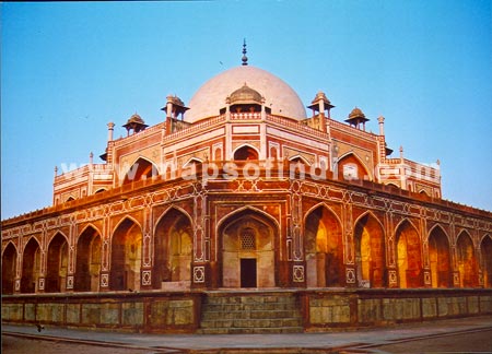
Also called Lal Quila, it is located in the walled city of Old Delhi by the banks of river Yamuna. This stunning piece of Mughal architecture was built by Shah Jahan during 1638-1648. Built using red sandstone, its walls extends a length of 2.4 Kms and a height varying from 18 meters to 33 meters. This is also a place where priceless antiques, fake ivory jewellery, paintings and skillfully woven carpets are sold to the tourists. 

In the central part of the Lal Kila fort is Nauba Khana (Drum House) where musicians of the emperor used to play for the royal household. The arrival of the princes and the royal family is also heralded from here. Mogul architecture can be seen inside the fort here. Other attractions in the fort complex include:
Rang Mahal (Palace of Colours) which is a lotus-shaped fountain made out of a single piece of marble and was used as living quarters for emperor's wives and mistresses

Sheesh Mahal and Khas Mahal are also special attractions in the fort complex.  

Every year on August 15th, the day of Indian Independence, the Prime Minister of India would address the nation from the Red Fort.  Another attraction of the Red Fort (Lal Killa) is the Sound and Light Show which is a 62 minute audio visual spectacular showcasing the history of Delhi and that of the fort. Tourists as well as locals usually come to this place to get away from the hustle and bustle of the city life and enjoy an evening in the serene atmosphere of the plush green lawns inside the walls of the fort. 

Nearest Metro station for Lal Kila is Chandni Chowk

Visiting Hours: 9:30AM to 4:30PM daily (except Monday) 

Entry Fee: Rs.10/-(For Indian Citizens) and Rs.150/- (For foreigners)

Entry Fee for Sound and Light Show: Rs.50/-


Qutab Minar

Qutab Minar at DelhiQutub-ud-din Aibak laid the foundation for Qutub Minar in 1199 AD and his successor and son-in-law Shamsu'd-Din- Iitutmish completed the structure by adding three more stories. Standing at 72.5 meters, it is the highest stone tower in India. Its base diameter is 14.3 meters and its top diameter is 2.7 meters. It has 379 steps leading to its top story. The lower three stories are made using red sand stone and the top two with marble and sand stone. There are various stories being told about the reason the Qutub minar was built. Some say that it was constructed as tower of victory to declare the might of Islam. Some others have the view that it might have been used as a tower for defense. The inscriptions at the base of the minaret tell that Firoz Shah Tughlak (AD 1351-88) added the last story in 1368. It is also believed that Sikandar Lodhi(AD 1489-1517) and Major R. Smith (1829) have undertaken several repair and restoration works on the tower. There are a numerous other Arabic inscriptions on the tower telling the history of Qutub. Other structures in the Qutub complex include: Tomb of Iitutmish, which was constructed in 1235 AD. The tomb is made up of red sandstone and it describes the Arabic architectural patterns..

 Quwwat-ul-Islam  

A mosque constructed by Qutub-ud-din in 1198 also stands in the Qutub complex. A famous Iron Pillar, which was erected in the 4th Century AD, is located in the courtyard of Quwwat-ul-Islam. It raises to a height of 7 meters and weighs more than 6 tons. The Sanskrit inscriptions on the pillar tells that it is erected as a flagstaff in honour of hindu god Vishnu and the memory of Chandra Gupta. It is made up of 98% wrought iron and it stood the test of time of more than 1600 years with our rust or decomposition. This proclaims the metallurgical excellence of ancient India. There are many other installations like madrassas, graves, tombs, mosques in the vicinity of Qutub Minar. Interestingly Qutub Minar is the most visited tourist spot in Delhi.

Timings: Sunrise - Sunset
Entry Fee: Indian Citizens: Rs.10. Foreigners : Rs.250
Camaras allowed inside the complex. 

 Nigh View Of Qutab Minar 


Prambanan


Prambanan in IndonesiaRakai Pikatan started construction on the largest Hindu Temple of Java, Prambanan, as an answer to Buddhist temples nearby. Prambanan’s construction was most likely meant to signify the return of the Sanjaya dynasty to power in Central Java. A temple was first built around 850CE by Rakai Pikatan to honor lord Shiva. Shiva-grha, or the House of Shiva, was the original name of the temple. Many archaeologists suggest that the idol of Shiva located in the central chamber of the main temple is modeled after King Balitung. Experts believe this idol represents a depiction of the king’s deified self after death.
The temple complex was expanded by Mataram kings Daksa and Tulodong. They also added hundreds of temples around the chief temple. Most of the state’s religious ceremonies took place at Prambanan because it served as the royal temple of Mataram, a Hindu Kingdon. Hundreds of Brahmins are said to have lived at Prambanan at the height of the Mataram kingdom. Scholars also believe that their followers lived within the outer wall of the temple complex. The urban center of Prambanan and their courts were said to be located in the nearby Prambanan valley.
A new dynasty, the Isyana Dynasty, took over in the 930s, and they shifted the court to East Java. Experts believe that either a volcanic eruption or power struggle caused the move, which marked the beginning of Prambanan’s decline. It began to deteriorate shortly after it was abandoned. The temples ultimately collapsed when a major earthquake hit in the 16th century, though there were no longer an important place of worship. A British surveyor accidentally stumbled upon the temples in 1811. A full survey of Prambanan’s ruins was ordered, but they still remained neglected for decades. Many sculptures and foundation stones were stolen by Dutch residents and used for construction material. More excavations took place by archaeologists in the 1880s, but they were done in a haphazardly manner and looting was the only result. Finally a reconstruction effort of the complex began in 1918, followed by proper restoration in 1930. The restoration of the main building of the temple complex was completed around 1953. So much of the original stonework has been stolen and reused, so restoration efforts have been slow. A temple can only be rebuilt only if builders can use at least 75% of the original masonry. For that reason, only foundations of many of the smaller shrines are visible today, and no plans for their reconstruction are evident. Restoration efforts continue today.


 Prambanan Visitor Information 

The nearest major cities to Prambanan are Yogyakarta, located 17 kilometres southwest, and Solo, which is about 40 kilometres northeast. There is a main road that connects these two large cities. It passes right by Prambanan and makes transport quite easy.  The town of Klaten is closest to Prambanan, located about 3 km north. UNESCO designated Prambanan a World Heritage Site in 1991. It became an increasingly popular tourist destination after that. You will need at least an entire day to get around and understand the historical significance of Prambanan. Prambanan opens early, at 6 AM, so staying nearby the previous night is a good idea. Getting in before the massive crowds arrive at 9am will afford you a good amount of time to explore with a limited amount of tourists. This will also afford the opportunity to visit some of the other archaeological sites on the Prambanan plain. This area of Java gets a lot of rain, so visiting from April to October give you the best chance of having a clear, sunny day. 237 temples comprise the Prambanan complex, though many of have deteriorated or been looted. Three zones make up the complex
  Night View Of Prambanan  


The Great Wall of China


The Great Wall of ChinaQin Shi Huang conquered all opposing states and unified China in 221 BC, establishing the Qin Dynasty. Intending to impose centralized rule and prevent the resurgence of feudal lords, he ordered the destruction of the wall sections that divided his empire along the former state borders. To protect the empire against intrusions by the Xiongnu people from the north, he ordered the building of a new wall to connect the remaining fortifications along the empire’s new northern frontier. Transporting the large quantity of materials required for construction was difficult, so builders always tried to use local resources. Stones from the mountains were used over mountain ranges, while rammed earth was used for construction in the plains. There are no surviving historical records indicating the exact length and course of the Qin Dynasty walls. Most of the ancient walls have eroded away over the centuries, and very few sections remain today. Later, the Han, Sui, Northern and Jin dynasties all repaired, rebuilt, or expanded sections of the Great Wall at great cost to defend themselves against northern invaders. The Great Wall concept was revived again during the Ming Dynasty following the Ming army’s defeat by the Oirats in the Battle of Tumu in 1449. The Ming had failed to gain a clear upper-hand over the Manchurian and Mongolian tribes after successive battles, and the long-drawn conflict was taking a toll on the empire. The Ming adopted a new strategy to keep the nomadic tribes out by constructing walls along the northern border of China. Acknowledging the Mongol control established in the Ordos Desert, the wall followed the desert’s southern edge instead of incorporating the bend of the Huang He. Towards the end of the Ming Dynasty, the Great Wall helped defend the empire against the Manchu invasions that began around 1600. Under the military command of Yuan Chonghuan, the Ming army held off the Manchus at the heavily fortified Shanhaiguan pass, preventing the Manchus from entering the Chinese heartland. The Manchus were finally able to cross the Great Wall in 1644, when the gates at Shanhaiguan were opened by Wu Sangui, a Ming border general who disliked the activities of rulers of the Shun Dynasty. The Manchus quickly seized Beijing, and defeated the newly founded Shun Dynasty and remaining Ming resistance, to establish the Qing Dynasty. In 2009, an additional 290 kilometres (180 miles) of previously undetected portions of the wall, built during the Ming Dynasty, were discovered. The newly discovered sections range from the Hushan mountains in the northern Liaoning province to Jiayuguan in western Gansu province. The sections had been submerged over time by sandstorms that moved across the arid region.


 The Great Wall of China Visitor Information 

The Great Wall can be visited on a day-trip from Beijing and is easily accessed by tour bus, public bus or by taxi. Many tour groups plump for the Badaling Section, as it is the closest to Beijing and has been open for the longest time to visitors (since 1957), though crowds vary widely across the various sections of the wall.  Official tourist sections of the Great Wall will have federal government tickets and cost from 30 RMB to over a 100 RMB depending on the location
  Night View Of  The Wall  


India Gate

Situated in Rajpath in Delhi the India Gate bears immense historical significance. A 42 meter high gateway built in red stone and granite the India Gate was planned by Sir Edwin Lutyen the architect who laid out the plan for Delhi. The foundation stone of India Gate of Delhi was laid by the Duke of Connaught. The construction of India Gate of Delhi was completed in February 1921. One of the most popular tourist destinations in the capital the India Gate today acts as a popular picnic spot for most of the tourists and citizens of Delhi. Also known as the 'All India War Memorial', the India Gate India Gate in Delhi was constructed as a memorial in honor of 90,000 soldiers who sacrificed their lives during World War I and also the Third Anglo Afghan War. 'Amar Jawan Jyoti' or the flame of the immortal warrior is burning under it since 1971. The eternal flame reminds one of the sacrifices of those brave soldiers who lost their precious lives in an attempt to protect the country. 

 India Gate in Delhi at present is a famous relaxation for the local people of Delhi in summer evenings and a popular picnic spot in winter months. The popular India Gate is located at the heart of the capital, and easily accessible by the tourists. Delhi India Gate lies at the east end of Janpath that leads to the Rashtrapati Bhawan.  India Gate offers a variety of entertainment. The whole day can be spent by watching monkey performance, riding a camel, viewing the soap bubbles that is blown all over the lawns of the India Gate, playing with balloons and more. In the evening, Delhi's India Gate is crowded with evening walkers as well as tourists and mobile vendors. You can taste the typical Indian fast foods, 'fruit chaat', 'bhelpuri', 'chana jor garam', 'dal ka pakodas', aerated drinks from the arcade of vendors stationed there.

 India Gate Site 

he 42-metre tall India Gate is situated such that many important roads spread out from it. Traffic passing around India Gate used to be continuous until the roads were closed to the public due to terrorist threats. The lawns around Rajpath throng with people during the evening, when the India Gate is lit up. Ice cream and street food vendors come out during this time and it becomes a popular picnic venue for families. The India Gate hexagon complex covers approximately 306000m² in area with a diameter of about 625m. The Republic Day Parade starts from Rashtrapati Bhavan and passes through India Gate to reach Red Fort.

 Night view Of Gate 

Colosseum

he Colosseum is probably the most impressive building of the Roman empire. Originally known as the Flavian Amphitheater, it was the largest building of the era. The monumental structure has fallen into ruins, but even today it is an imposing and beautiful sight. Emperor Vespasian, founder of the Flavian Dynasty, started construction of the Colosseum in AD 72. It was completed in AD 80, the year after Vespasian's death.The huge amphitheater was built on the site of an artificial lake, part of Nero's huge park in the center of Rome which also included the Golden House (Domus Aurea) and the nearby Colossus statue. This giant statue of Nero also gave the building its current name.
  The Building  


Colosseum, Rome
by 156m and reaching a height of more than 48 meter (159 ft). The Colosseum could accommodate some 55,000 spectators who could enter the building through no less than 80 entrances.Above the 
ground are four storeys, the upper storey contained seating for lower classes and women. The lowest storey was preserved 
for prominent citizens. Below the ground were rooms with mechanical devices and  cages containing wild animals. The cages 
could be hoisted, enabling the animals to appear in the middle of     the arena.                                                                                               
   Velarium  

The Colosseum at night
The Colosseum was covered with an enormous awning known as the velarium. This protected the spectators from the sun. It was attached to large poles on top of the Colosseum and 
anchored to the ground by large ropes. A team of some 1,000 men was used to install the awning.

  Inside View Of Colosseum   


   Inauguration  

The colosseum at night
Hundred-day games were held by Titus, Vespasian's 
successor, to mark the inauguration of the
building in AD 80. In the process, some 9,000
wild animals were slaughtered.

  The Ruins   
The southern side of the Colosseum was felled by an earthquake in 847. Parts of the building - including the marble facade - were used for the construction of later monuments, including the